Geography Class 18
Types of Mass Movements.
- Slow:
- Creep: The slow downhill movement of the soil and weathered mantle along the mountain slopes.
- It is a continuous movement but difficult to notice
- Solifluction: It involves the slow movement of soil mixed with water as a viscous fluid
- It is more active in glacial areas
- Rapid:
- Landslide: A landslide is the movement of a cross-section of a hill slope under the influence of gravity is called as landslide
- The material maintains continuous contact with the surface as it moves
- Avalance: Similar to landslides, is sudden collapse and sliding of snow-covered regions
- Earthflow: Thye occur along terraces and hillsides that are capable of flowing as a single unit when saturated with water below the top layer
- Mudflow: It involves the rapid movement of masses of uncompacted soil ie suddenly saturated with water
- Rock slide/fall: It is a rapid movement including rock material either sliding along the mountain slopes (rock slide) or falling vertically
Landforms:
- Agent and its topography:
- River - Fluvial Topography
- Ground - Karst topography
- Waves - marine Topography
- Wind - Desert or Arid Topography
- Glacier - Glacial topography
- Each causes erosional as well as depositional topography
Riverine Topography:
- It is a topography which is built by riverine erosional and deposition
- 3 stages in riverine topography: Youth Stage, Mature Stage, and Old Stage
Index Youth Stage Mature Stage Old Stage Slope High Moderate Low Energy High Moderate Low Erosion High - Vertical Moderate Lateral Low or No erosion Deposition Very low Moderate High Meandering No Moderate High
Features of Riverine Topography:
Topography Processes Erosional Depositional - Riverine (Agent - River water)
- Corrasion
- Attrition
- Cavitation
- Corrosion
- Hydraulic
- V-Shaped Valleys
- V-Shaped Valleys
- Gorge and Canyon
- Waterfall, Cataract, Rapids
- Plunge pools and Pot Holes
- River Capture and wind Gap
- Meander - River Cliff
- Slip of slope
- Levee
- Flood Plain
- Ox-Bow lakes
- Alluvials fans and Delta
- Estuary
Geography Class 19
A brief overview of the previous class i.e. Landforms of riverine topography
Karst Topography/ Limestone topography
- [* If Fresh water is 100 units then 67-68 units are ice caps, 30 units are groundwater, 1-1.5 units are water vapor, and 0.3 units are water in rivers, lakes, etc]
- Underground Rock systems are called Aquifers
- When water (Containing carbonic acid) falls on the surface, It melts the rocks very easily. It will sip in and joins the groundwater

- This term was used in Eastern Europe, erstwhile Yugoslavia.
- Many large Caves are found- in erstwhile Yugoslavia, countries of Southeast Asia[Thailand, malyasia], Meghalaya, Mexico - Yucatan peninsula [The meteorite fell here led to the extinction of the dinosaurs, Mayan civilization flourished here, devoid of surface Fresh water, they survived through the Karst topography], Western Australia, In India these are found in Meghalaya
Topography Processes Erosional features Depositional features Karst/ Groundwater Conditions that led to this karst topography
- Soft and Permeable rocks in the upper layer of lithosphere such as limestone, dolomite
- Moderate to heavy precipitation
- Hard strata of rocks at the sub-surface level
Processes
- Corrasion
- Corrosion
- Attrition
- Carbonation
- Hydrolysis
[Less hydraulic action, No or less attrition ]
Features
- Sinkholes are created- very wide and huge depression
- Swallow hole- Shallow version of sinkholes
- Doline- Sinkholes merge together to form Doline
- Uvala- Dolines merge together to form Uvala [Refer to the below diagram]
- Blind valley/karst valley- The river disappears and only valleys are visible, the rivers flow underground.
- Caves- Ground water creates caves Example- Mexican caves, Meghalaya caves
Features
- Stalactites- These develop from the roof from the dripping water
- Stalagmites- The deposits develop upward from the floor.
- Cave Pillar- When both the stalactites and stalagmites meet.
[Important activity- Cave diving]
Regions Erstwhile Yugoslavia, South-East Asia, Meghalaya in NE India, Mexico, Western Australia
Marine Topography
- Agent- Waves
- Source of energy- WInd (Driven by sunlight due to differential heating)
- Erosion and deposition are dependent on the type of coast
- If forward force is more then it will lead to erosional features whereas if backward force is more then it will lead to Depositional features
- On the eastern coast deposition happens and on the Western coast erosion happens (The exception is the Kerala coast)
- Processes- Corrasion, Attrition, Cavitation, Corrosion, Hydraulic action (No deflation, no plucking)
Erosional features
- Cliffs- Near to coastal region [due to erosion-steep slope]
- Wave cut platforms- Upper part is eroded but the lower part is not eroded [The lower part is hard rock], a platform is left due to differential erosion
- Bay- Too much erosion on the inner side, and wave action is more. And it creates a semi-circle shape [Differential erosion] {* Gulf is not a part of marine topography, it is a waterbody+ Gulf have narrow mouth or elongated mouth. For example- the Persian gulf, and Mexican Gulf}. When the Mouth of the Gulf is too wide then it is called a Bay. Example- the Bay of Bengal, Hudson bay.
- Hanging valley - It is a river valley that ends abruptly into the coastal region. That river valley is hanging into the ocean. For Example- Found in Norway.
- Sea caves- Due to continuous waves hitting the cliffs, creates caves from the seaside
- Sea arch or natural bridge- Development of sea caves from both sides, Gradually it will deepen and merge together. When two sea caves merge together it is called a sea arch.
- Sea stack- When the roof of an arch is broken by erosion or under its own weight or due to any other reason a part of the original rock remains standing as a solitary mass. It may be the rock forming the side of the arch. This type of feature is called a sea stack.
- Sea stump- The smaller version of the sea stack is called the sea stump
- Blow holes- When a powerful wave hits, it creates a hole in the upper part. Then the water comes out from the blow holes

Depositional features
- Wave-built platform- When the sea recedes and due to the deposition of sand a platform can be built, for Example- near the bay
- Beach- Where the wave speed reduces and the deposition of sand is more. In India, along the eastern coast, we have more no. of beaches [The longest is Marina beach, Chennai]
- Off-shore sand bars-When the slope is less and the water level is also less, then it creates the feature of sand bars. Sand bars not connected to the land are called offshore sand bars [Mostly found on the East coast, one of the sand bars is strategically located in Sriharikota (ISRO satellite center, on Pulicat lake)]
- Sand spit- When the sand bar is connected on one end with land
- Tombolo- When the sand bars are connected on two sides with the land.
- Lagoons- A lake near the coastal region is called a lagoon. It is separated from the main part. [* Kerala state is known for the backwaters, houseboats, etc]

Arid/ Desert topography
- Agent - Wind [It is more of physical weathering due to sunlight], Erosion [Wind is at very high speed, as there is no vegetation]
- Erosional Process involved- Attrition, Abrasion, Deflation (Lifting action of wind) [No corrosion, cavitation as they require water], No plucking
- [* Reasons for Desert formation- Low precipitation less than 25 cm]
Erosional features
- Deflation hollows- The hollows or empty spaces created by the winds. These are created by Deflation
- Ventifacts- Abrasion causes the polishing of the surfaces, and the polished surfaces are called ventifacts
- Mushroom Rocks- Rocks near the surface go faster weathering than the above one [Wind action is faster, as sands carried by the wind are below], this creates the mushroom rocks. (Caused by Abrasion near the surface)
- Zeugen- Continuous layer of hard and soft rocks in a Vertical direction, Soft rocks will easily be eroded. Differential erosion will lead to Zeugen. It is caused by abrasion
- Yardungs- When differential rocks are there in a horizontal position.
- Inselbergs- Remanant of hills. In the central part, the hard rocks are there which take a longer time to erode.
Depositional features/ landforms
- Sands are more in the desert because of attrition
- Sand dunes- famous beaches- Thar desert [Marusthali], Ladakh [Nubra valley- Hundar sand dunes], Arabian sand dunes [Rub-al-khali sand dunes], Namib desert [The largest sand dunes are in Namib desert]
- Barchans- crescent-shaped sand dunes are called barchans. If the limbs are in the direction of the wind
- Parabolic-shaped sand dunes- if limbs are opposite to the direction of the wind
- Seif- Barchan with one limb
- Transverse sand dunes- Perpendicular to the direction of the wind
- Longitudional sand dunes- Parallel to the direction of the wind
- Bolson lake/Playas lake- Refer to the diagram [Above]
- Oasis- Fertile land around the playas region
- Pede-plain- Pediplains are formed when high relief features in deserts are lowered to low featureless plains due to wind activity. The convergence of pediments forms a Pede-plain, which is a largely flat landscape

Glacial Topography
- Formed along the mountain sides,
- During winter- when snow is deposited on the mountain sides, a thin layer of snow is created. Where there is more depression, more accumulation of snow occurs. Water will sip into the gaps of the snowflakes and it will get harden. Through continuous melting and freezing, it becomes a thick block of ice
- During summer- The entire block of ice will start to melt from its base. It will start to move. It has a very high erosional capacity
- Agent- Glaciers [Capable of movement, largest force]
- Process involved- Abrasion, plucking, erosion
- [* 5 Big lakes are the result of glacial erosion]
Erosional features
- Nivation hollows- Small depressions where the glaciers start to build up [from mountain size to huge glacier]
- Cirque- Continuous circulation of the glacier, enlarged depression
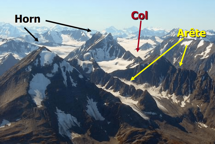
- Arete- It separates two Cirques
- Horn- When cirques are developed from all sides, and the top mountain becomes too narrow and steep. For example- Matterhorn [Alps mountain], Kailash mountain, Mt. Everest
- Col- When the horn is entirely eroded and the upper part is removed. Indira col [North of siachen]
- U-shaped valley- It is the valley created by the glaciers. When multiple glaciers merge together.
- Hanging valley- Small U-shaped valley merging with the big U-shaped valley.
- Fjords- The U-shaped valley directly enters the ocean [Norway is known for Fjords]
Depositional features
- Moraines- Unstratitifed mix of sand and ice carried by a glacier- lateral, medium, end moraines, and at the base is called Ground moraines
- Moraine capped lakes- When these lakes outburst it is called GLOF [Glacier lake outburst flood- example- Chorabari lake- north of Kedarnath]
- Tillites- It is a heterogeneous mixture of Clay and Till from pre-historic times
- Drumlins- Semicircle depositions are called baskets of egg topography or Drumlins
- Esker- When it is forming a longitudinal ridge it is called Esker
Concise mind map for the topics covered in Geography Class 18 and 19:
Geography Class 18
1. Types of Mass Movements
- Slow Movements
- Creep: Slow, continuous downhill soil movement
- Solifluction: Slow soil movement mixed with water, common in glacial areas
- Rapid Movements
- Landslide: Downhill movement of soil/rock due to gravity
- Avalanche: Sudden snow collapse and sliding
- Earthflow: Flow of saturated soil along terraces/hillsides
- Mudflow: Rapid soil movement saturated with water
- Rock Slide/Fall: Rapid movement of rock materials
2. Landforms by Agents
- River: Riverine Topography
- Youth Stage: High energy, V-shaped valleys, low deposition
- Mature Stage: Moderate energy, meanders, moderate erosion/deposition
- Old Stage: Low energy, extensive deposition, ox-bow lakes, flood plains
- Ground: Karst Topography
- Waves: Marine Topography
- Wind: Desert or Arid Topography
- Glacier: Glacial Topography
Geography Class 19
1. Review: Riverine Topography
2. Karst Topography
- Conditions: Soft, permeable rocks, moderate precipitation
- Processes: Carbonation, corrosion, attrition
- Features:
- Sinkholes: Large depressions
- Caves: Formed by groundwater, e.g., Mexican caves
- Stalactites/Stalagmites: Cave formations
- Regions: Meghalaya, Mexico, Southeast Asia
3. Marine Topography
- Processes: Corrasion, attrition, hydraulic action
- Erosional Features:
- Cliffs: Steep coastal slopes
- Wave-cut Platforms: Eroded coastal platforms
- Sea Arches/Stacks: Formed by wave erosion
- Depositional Features:
- Beaches: Sand deposition
- Sand Bars/Spits: Coastal sand formations
- Lagoons: Coastal lakes
4. Arid/Desert Topography
- Processes: Attrition, abrasion, deflation
- Erosional Features:
- Deflation Hollows: Wind-carved depressions
- Ventifacts/Mushroom Rocks: Wind-polished rock formations
- Depositional Features:
- Sand Dunes: Various shapes (Barchans, Seifs)
- Oasis: Fertile areas around playas
5. Glacial Topography
- Processes: Abrasion, plucking
- Erosional Features:
- Cirques: U-shaped valleys
- Aretes/Horns: Sharp ridges and peaks
- Fjords: Glacial valleys entering the sea
- Depositional Features:
- Moraines: Glacially deposited sediments
- Drumlins: Egg-shaped hills
- Eskers: Longitudinal ridges
50 short-answer questions based on your notes:
What is creep in mass movements?
- The slow downhill movement of soil and weathered mantle along mountain slopes.
What is solifluction?
- The slow movement of soil mixed with water as a viscous fluid, more active in glacial areas.
Define landslide.
- The movement of a cross-section of a hill slope under the influence of gravity, maintaining contact with the surface.
What characterizes an avalanche?
- Sudden collapse and sliding of snow-covered regions.
Describe an earthflow.
- The movement of a mass of saturated soil that flows as a single unit along terraces and hillsides.
What is a mudflow?
- The rapid movement of masses of uncompacted soil suddenly saturated with water.
Differentiate between a rock slide and a rock fall.
- A rock slide involves rock material sliding along slopes, while a rock fall involves rocks falling vertically.
What topography is formed by rivers?
- Riverine Topography.
List the three stages of riverine topography.
- Youth Stage, Mature Stage, Old Stage.
What is the slope like in the Youth Stage of riverine topography?
- High.
How does erosion differ between the Youth and Old Stages of riverine topography?
- High vertical erosion in Youth Stage and low or no erosion in Old Stage.
Name an erosional feature of riverine topography.
- V-Shaped Valleys.
What is a meander in riverine topography?
- A bend or curve in a river, prominent in the Old Stage.
Where is Karst topography most commonly found?
- Regions like erstwhile Yugoslavia, Southeast Asia, Meghalaya, and Mexico.
What causes the formation of sinkholes?
- The dissolution of soluble rocks such as limestone by groundwater.
What is a swallow hole?
- A shallow version of a sinkhole.
Describe a doline.
- A depression formed when multiple sinkholes merge.
What is a stalactite?
- A deposit that forms from the ceiling of a cave due to dripping water.
How does a stalagmite differ from a stalactite?
- A stalagmite forms from the floor of a cave due to dripping water.
What is a sea arch?
- A natural bridge formed when two sea caves merge.
Define a sea stack.
- A solitary mass of rock left standing after the roof of a sea arch collapses.
What causes blowholes?
- Powerful waves hitting the coastal rocks, creating holes through which water shoots out.
Explain the term "tombolo."
- A sand bar that connects two land masses.
What type of topography is created by wind?
- Desert or Arid Topography.
What are ventifacts?
- Rock surfaces polished by wind abrasion.
Describe a barchan.
- A crescent-shaped sand dune with limbs in the direction of the wind.
What is a pediplain?
- A flat landscape formed by the erosion of high relief features to low, featureless plains.
What creates a sand spit?
- A sand bar connected at one end to land.
Define a lagoon.
- A lake near the coast separated from the sea by a barrier.
What is an inselberg?
- A remnant hill in a desert with a hard core resistant to erosion.
How do glaciers contribute to topography?
- By causing erosion and creating features like U-shaped valleys and fjords.
What is a cirque?
- An enlarged depression formed by continuous circulation of a glacier.
Define an arete.
- A ridge that separates two cirques.
What is a horn in glacial topography?
- A steep, narrow peak formed by glaciers on all sides.
What causes a hanging valley?
- A small U-shaped valley that merges with a larger U-shaped valley.
Describe a fjord.
- A U-shaped valley that enters the ocean, often found in places like Norway.
What are moraines?
- Unstratified deposits of sand and ice carried by a glacier.
Explain the term "drumlin."
- A semicircular deposit of glacial till, often referred to as "basket of eggs" topography.
What is an esker?
- A long, winding ridge formed by sediment deposited by a glacier.
Describe a col.
- A low point or pass between two peaks created by erosion.
What is a tillite?
- A mixture of clay and till from pre-historic glacial periods.
What type of landform is a wave-built platform?
- A feature created by the deposition of sand when the sea recedes.
Define a deflation hollow.
- A hollow created by wind erosion, where the wind removes material.
What is a zeugen?
- A landform created by the differential erosion of hard and soft rock layers.
Describe a parabolic-shaped sand dune.
- A dune with limbs opposite to the direction of the wind.
What is a sand dune?
- A hill of sand formed by wind deposition, common in deserts.
How does a sea stack form?
- It forms when the roof of a sea arch collapses, leaving a solitary rock column.
What is the primary cause of arid or desert topography?
- Wind erosion due to high-speed winds and low vegetation.
What is a bolson lake or playa lake?
- A dry lake found in desert regions, often filling with water temporarily after rain.
Explain the term "hanging valley."
- A small valley that ends abruptly where it meets a larger valley or fjord.
Five long-answer type questions based on your notes, along with their answers:
Question 1:
Describe the different types of mass movements and explain the key characteristics and mechanisms of each type. How do these movements impact landscapes?
Answer: Mass movements are categorized based on their speed and the nature of the movement. They can be classified into slow and rapid movements:
Slow Movements:
- Creep: Creep is the slow, gradual downhill movement of soil and weathered material on slopes. It is often imperceptible over short periods but becomes noticeable over long periods as it results in the displacement of objects, like tilted trees and fences.
- Solifluction: This involves the slow, viscous flow of soil saturated with water, primarily occurring in glacial and periglacial environments. It often affects areas with permafrost where the top layer becomes fluid-like due to thawing.
Rapid Movements:
- Landslide: A landslide is the sudden, fast movement of a mass of rock or soil down a slope due to gravity. The material maintains continuous contact with the surface as it moves, which can cause significant alterations to the landscape, such as the formation of new scarps and debris fans.
- Avalanche: Similar to landslides but involving snow, avalanches are the sudden collapse and sliding of snow on slopes. They can cause substantial changes in the topography by burying landscapes under thick layers of snow and debris.
- Earthflow: This occurs when saturated soil flows downhill as a cohesive mass. It often forms on hillsides and terraces, where the top layer becomes overly saturated with water, leading to a mass movement.
- Mudflow: Mudflows involve the rapid movement of wet, unconsolidated soil and debris, often triggered by heavy rainfall or volcanic activity. They can cause extensive damage by rapidly inundating areas with a fast-moving, fluid mass of mud.
- Rock Slide/Fall: Rock slides involve the rapid sliding of rock material down a slope, while rock falls are characterized by the vertical free fall of rocks from a height. Both types of movement can create dramatic changes in the landscape, including the formation of talus slopes and new cliffs.
These mass movements significantly impact landscapes by reshaping slopes, creating new landforms, and causing erosion and deposition.
Question 2:
Explain the different types of topographies created by rivers and the processes involved in their formation. How do these topographies evolve through different stages?
Answer: Riverine topography is shaped by the actions of rivers through erosion and deposition, and it evolves through three main stages:
Youth Stage:
- Characteristics: In this initial stage, rivers exhibit a high gradient and significant vertical erosion. The landscape features steep, V-shaped valleys, with high energy and rapid erosion.
- Processes: Key erosional processes include corrasion, attrition, cavitation, and hydraulic action. Deposition is minimal at this stage.
Mature Stage:
- Characteristics: The river gradient moderates, and the valley begins to widen. Erosion becomes more lateral than vertical. Features such as meanders start to develop.
- Processes: Lateral erosion dominates, leading to the formation of features such as meander loops and river cliffs. Deposition increases, resulting in the formation of features like floodplains and ox-bow lakes.
Old Stage:
- Characteristics: At this stage, the river has a low gradient and low energy. The valley is wide and flat, with extensive deposition.
- Processes: Erosion is minimal, focusing more on lateral processes. Depositional features become prominent, including alluvial fans, deltas, and estuaries. The river meanders extensively, and features like levees and floodplains become well-developed.
Riverine topography includes various features such as V-shaped valleys, gorges, waterfalls, cataracts, and meander loops. These landforms evolve as the river progresses from the youth stage to the mature and old stages, reflecting changes in the energy and sediment load of the river.
Question 3:
Discuss the formation of karst topography and its distinctive features. What are the key processes involved, and how do these features contribute to the overall landscape?
Answer: Karst topography is formed primarily through the dissolution of soluble rocks like limestone, dolomite, and gypsum by slightly acidic water. The distinctive features and processes involved are as follows:
Key Processes:
- Carbonation: This is the primary process where carbonic acid in rainwater dissolves limestone, leading to the formation of karst features. The dissolution creates voids and cavities in the rock.
- Corrosion and Hydrolysis: These processes further contribute to the dissolution of rock material, enhancing the development of karst landscapes.
Distinctive Features:
- Sinkholes: Large depressions formed by the collapse of the surface layer into an underlying void. These can vary from small pits to large craters.
- Swallow Holes: Smaller depressions where surface water enters and disappears into the underground drainage system.
- Doline: Formed when multiple sinkholes merge together, creating a larger depression.
- Uvala: A larger depression formed by the merging of several dolines.
- Caves: Formed by the continuous dissolution of rock, leading to extensive underground systems. Examples include the caves in Mexico and Meghalaya.
- Stalactites and Stalagmites: Mineral formations in caves where water dripping from the ceiling forms stalactites (icicle-shaped) and those deposited on the floor form stalagmites (pillar-shaped). When they meet, they form a cave pillar.
Karst topography contributes to the overall landscape by creating unique landforms and influencing groundwater flow patterns. It often results in dramatic and rugged terrains, characterized by sinkholes, underground rivers, and extensive cave systems.
Question 4:
Analyze the processes and features associated with marine topography. How do waves contribute to the formation of erosional and depositional features along coastlines?
Answer: Marine topography is shaped by the actions of waves and associated processes, which create both erosional and depositional features along coastlines. The processes and features involved are as follows:
Erosional Features:
- Cliffs: Formed where waves erode the base of a steep coastal slope, creating a vertical or near-vertical face.
- Wave-Cut Platforms: Flat areas at the base of cliffs formed by the continuous erosion of the lower part of the cliff, leaving a platform behind.
- Sea Caves: Created by the erosional action of waves on coastal cliffs, resulting in hollowed-out areas.
- Sea Arches: Formed when two sea caves on opposite sides of a headland merge, creating an arch-like structure.
- Sea Stacks: Isolated columns of rock remaining after the collapse of a sea arch. These are remnants of the original headland.
- Hanging Valleys: Formed when a valley carved by a glacier ends abruptly at the coastline, often leading to waterfalls.
Depositional Features:
- Beaches: Formed where waves deposit sand and other sediments in areas where the wave energy decreases.
- Sand Spits: Created when longshore drift deposits sand in a narrow, elongated formation connected to the mainland.
- Tombolos: Formed when sand bars connect an island to the mainland.
- Lagoons: Shallow bodies of water separated from the open sea by a barrier such as a sandbar or coral reef.
- Offshore Sand Bars: Sand accumulations located offshore, often parallel to the coastline.
Waves contribute to the formation of these features through processes such as corrasion, attrition, cavitation, and hydraulic action. Erosional processes dominate where wave energy is high, leading to the creation of cliffs, sea caves, and arches. Depositional processes dominate where wave energy is lower, leading to features such as beaches, spits, and lagoons.
Question 5:
Describe the key features of desert topography and the processes responsible for their formation. How do wind-driven processes contribute to both erosional and depositional landforms in arid regions?
Answer: Desert topography is characterized by features formed primarily through wind-driven processes, as well as the impact of low precipitation and high temperatures. The key features and processes are:
Erosional Features:
- Deflation Hollows: Depression formed by the removal of loose, fine sediments by wind action. These hollows create empty spaces in the desert floor.
- Ventifacts: Rocks that have been polished and shaped by wind-driven sand and particles. The surfaces of these rocks exhibit a smooth, polished appearance.
- Mushroom Rocks: Rocks with a mushroom-like shape, formed when wind erosion wears away the base of the rock more rapidly than the top.
- Zeugen: Steep-sided ridges formed by the differential erosion of alternating layers of hard and soft rock, resulting in a ridge-like landform.
- Yardangs: Sharp, elongated ridges formed by the erosion of rock layers aligned perpendicular to the wind direction.
Depositional Features:
- Sand Dunes: Formed by the accumulation of sand transported by wind. Different types include barchans (crescent-shaped dunes), parabolic dunes (with arms pointing away from the wind), and longitudinal dunes (parallel to wind direction).
- Bolson Lakes/Playas: Depressions in the desert where water accumulates temporarily, forming lakes that dry up and leave behind salt flats.
- Oasis: Fertile areas in deserts where groundwater emerges to create a localized environment of vegetation and water.
- Pediplains: Flat, expansive plains formed by the erosion and lowering of high relief features due to wind activity.
Wind-driven processes such as attrition, abrasion, and deflation are key to shaping desert landscapes. Erosional features are created through the mechanical action of wind and sand, while depositional features result from the accumulation of sand and sediment transported by wind. These processes lead to the formation of diverse and unique landforms characteristic of desert environments.
Class 18
1)
Mass movement is the movement of surface material caused by gravity. Which of the following comes under the phenomena of mass movement?
- Soil creep
- Weathering
- Landslide
Select the correct answer from the codes given below:
(a)1 and 2 only
(b)1 and 3 only
(c)2 and 3 only
(d)1, 2 and 3
2)
Consider the following statements:
1. Levees are only found in the old stage of a river.
2. V-shaped valleys are formed in the youthful stage of rivers.
3. Oxbow lakes are found in the mature stage of the river.
Which of the statements given above is/are not correct?
(a)1 only
(b)1 and 3 only
(c)2 and 3 only
(d)1, 2 and 3
3)
Consider the following statements:
1) Erosion is the breakdown of rocks in movement.
2) Mass movement is the in-situ breakdown of rocks.
3) Weathering happens under the influence of gravity.
Which of the following statements is/are correct?
(a)1 only
(b)1 and 2 only
(c)2 and 3 only
(d)1, 2 and 3
4)
With respect to Ox-Bow lakes, choose the correct statement(s) :
- The oxbow lake is created over time as erosion and deposits of soil change the river"s course.
- In the Indo-Gangetic plains, the southwards shifting of the Ganga has left many ox-bow lakes to the north of the present course of the Ganga.
Choose the correct option:
(a)1 only
(b)2 only
(c)Both 1 and 2
(d)Neither 1 nor 2
5)
Which of the following is/are correct with respect to Debris avalanches and landslides?
1. They are a type of slow mass movement.
2. The presence of sedimentary rocks, and unconsolidated and semi-consolidated deposits increases the chances of a landslide and avalanche.
3. The Himalayan region is prone to debris avalanches and landslides.
Select the correct answer from the codes given below:
(a)1 only
(b)1 and 2 only
(c)2 and 3 only
(d)1, 2 and 3
6)
Consider the following statements:
- Meanders are associated with cliff slopes and slip off the slope.
- The cliff slope zone is the zone of Deposition
- The slip-off zone is the Zone of erosion.
Which of the statements given above is/are not correct?
(a)1 and 2 only
(b)2 and 3 only
(c)1 and 3 only
(d)None of the above.
7)
Consider the following statements:
- Meanders generally can occur at any stage but it is more prominent in the mature and old stage of the river.
- Delta is a completely depositional feature formed near the origin of the river.
Which of the statements given above is/are correct?
(a)1 only
(b)2 only
(c)Both 1 and 2
(d)Neither 1 nor 2.
8)
Consider the following statements with respect to the mass movements and mass wasting :
- Mass wasting is the removal of weathered material from the upper steeper slopes and not focusing much on removal from gentler slopes
- Mass movement on the other hand is a comprehensive process focusing on the removal of the whole slope from the upper parts up to the lower parts
Which of the statements given above is/are correct?
(a)1 Only
(b)2 Only
(c)Both 1 and 2
(d)None of the Above
9)
Consider the following with respect to the types of Mass Movements:
- Earthflow happens on slopes having weathered soil saturated with water but loosely held by vegetation
- Mudflow happens in regions which are devoid of vegetation cover
- Debris Avalance is the movement of material like an avalanche
How many of the statements given above is/are correct?
(a)Only one
(b)Only two
(c)All three
(d)None of the Above
10)
Consider the following statements:
1. Lateral erosion dominates the Youth stage of a river.
2. Degree of meandering in the youth stage is more than that of the Old stage.
Which of the statements given above is/are correct?
(a)1 only
(b)2 only
(c)Both 1 and 2
(d)Neither 1 nor 2
11)
Explain different types of mass movements. Enumerate the reasons for mass movements in the Himalayas and the Western Ghats.(150 words/10 marks)
12)
Briefly discuss the fluvial landforms created in the various stages of rivers. (150 words/10 Marks)
Answers
1) b
2) a
3) a
4) c
5) c
6) b
7) a
8) c
9) c
10) d
Enumerate the forces dominant in the Youth stage of the river. Also, discuss the landforms associated with the youthful stage of river. (150 Words/10 marks)
Class 19
1)
Karst topography is found mainly in regions characterized by:
(a)
Alluvial fans
(b)
Glacial outwash plains
(c)
Limestone bedrock
(d)
Loess
2)
Consider the following statement about Karst topography:
- Karst topography is a landscape formed from the dissolution of soluble rocks such as limestone.
- It is characterized by underground drainage systems with sinkholes and caves
- Sinkholes and Uvala are erosional features of karst topography.
How many of the statements given above is/are correct?
(a)Only one
(b)Only two
(c)All three
(d)None
3)
With reference to Karst topography, consider the following statements:
1. Stalactites are sharp slender downward growing pinnacles that hang from cave roofs.
2. Stalagmites are calcium deposited from the cave roof growing upward.
Which of the statements given above is/are correct?
(a)1 only
(b)2 only
(c)Both 1 and 2
(d)Neither 1 nor 2
4)
Which of the following pairs are correctly matched?
- Nivation hollows- They are small depressions where the glaciers start to build up
- Cirque- Continuous circulation of the glacier and are enlarged depression
- Arete- It separates two Cirques
- Horn- When cirques are developed from all sides, and the top mountain becomes too narrow and steep
Select the correct answer from the codes given below:
(a)1, 2 & 3 only
(b)2& 3 only
(c)1,2,3 & 4
(d)1& 4 only
5)
How many pairs of the following types of moraines are matched correctly?
Types of Moraine The landforms made
(1) Terminal moraines They are long ridges of debris deposited at the end (toe) of the glaciers.
(2) Lateral moraines They are formed along the sides parallel to the glacial valleys.
(3) Ground moraines They are formed when retreating glaciers rapidly leave an irregular sheet of till over their valley floors.
Choose the correct code:
(a)Only one
(b)Only two
(c)All three
(d)None
6)
Zeugen, Yardang, Inselberg are landforms associated with which of the following topography?
(a)Riverine
(b)Karst
(c)Marine
(d)Desert
7)
Consider the following statements with respect to the Depositional Landforms:
- Drumlins are ridges made of sands and gravels, deposited by glacial meltwater flowing through tunnels within and underneath glaciers
- Eskers are oval-shaped hills largely composed of glacial till.
Which of the statements given above is/are correct?
(a)1 Only
(b)2 Only
(c)Both 1 and 2
(d)None of the Above
8)
Match the following
Places Location
1). Rub-Al-Khali sand dunes Saudi Arabia
2). Marusthali sand dunes Ladakh, India
3). Hundar sand dunes Thar desert, India
4). Matterhorn Switzerland
Which of the pairs are matched correctly?
(a)Only 1 pair
(b)Only 2 pairs
(c)Only 3 pairs
(d)All pairs are matched correctly
9)
Consider these statements regarding Marine Landforms:
1) Cliffs, Hanging valleys, and Sea caves are the Depositional features of the Marine landforms.
2) Off-shore Sand bars and tombolo are the Erosional features of Marine Landforms.
3) Chilika is an example of the off-shore sandbar.
How many of the statements given above is/are correct?
(a)Only one
(b)Only two
(c)All three
(d)None
10)
Explain the process of marine erosion. Also describe the various erosional marine landforms with examples?(150 words)
11)
Discuss the process involved, Erosional features, and depositional features in the Glacial topography (10 marks/ 150 words)
12)
Discuss the process involved, Erosional features, and depositional features in the Desert topography (10 marks/ 150 words)
Answers
1) c
2) c
3) a
4) c
5) c
6) d
7) d
8) b
9) d
What do you mean by "Karst Landforms"? Explain various types of Karst landforms with the help of diagrams and examples. (150 words/10 marks)


0 Comments