Geography Class 16
Earthquakes (continued)
- Causes of earthquake:
- Natural causes:
- Plate movements
- Volcanic eruption.
- Landsides.
- Land Subsidence.
- Meteoritic impact.
- Anthropogenic causes:
- Mining and blasting.
- Nuclear explosion.
- Reservoir-induced seismicity(RIS).
- The scientific study of earthquakes is called seismology.
Earthquake waves
- Diagrammatic representations of Earthquake waves:
- During an earthquake, the point where the energy is released below the surface is called the focus/hypocentre.
- The point on the surface nearest to the focus is called the epicentre.
- An earthquake generates two types of waves, body and surface waves.
- Body waves:
- These earthquake waves are generated at the focus and move through the earth's interior.
- There are two types of body waves, P-wave and S-wave.
- P-waves(Primary waves):
- These are the first to be detected during an earthquake.
- They are also called compressional waves and longitudinal waves.
- They oscillate back and forth in the direction of propagation.
- P-Waves depend on the density and rigidity of the material.
- P- waves can travel through solid, liquid, and gas.
- S-waves(secondary waves):
- S waves oscillate perpendicularly to the direction of propagation.
- They are also called transverse waves.
- The S-wave movement depends on the material's density and rigidity.
- Therefore S waves cannot pass through liquid and gas.
- Surface waves:
- These are the earthquake waves confined to the surface of the earth.
- They are generated due to the interaction of body waves with the surface and generally at the epicentre.
- Surface waves are much slower than body waves but cause more damage.
- Examples are Love waves and Raleigh waves.
Shadow zones
- Diagrammatic representation of shadow zones:

- The seismic waves undergo reflection, bending, or changes in direction while passing from one medium to another.
- This results in the creation of shadow zones.
- The Shadow zone is the zone in the earth's interior from where earthquake waves are not reported.
- P-wave shadow zone:
- P-waves are not detected between 105-145 degrees from the focus resulting in the P-wave shadow zone.
- It is due to a change in direction of P-waves as it enters the outer core.
- S-wave shadow zone:
- S-waves cannot pass through the liquid outer core.
- Therefore beyond 105 degrees, we observe S-wave shadow zones.
- By studying the different earthquake waves, the extent of their shadow zone, and other characteristics we can conclude about the earth's interior.
Type of earthquake
- Shallow focus earthquake occurs at the depth of 0-70 km.
- Intermediate focus earthquake occurs at the depth of 70-350 km.
- Deep-focus earthquake occurs at the depth of more than 350 km.
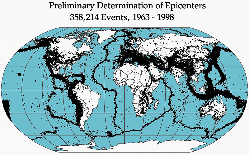
Distribution of earthquakes
- Circum-pacific belt:
- Around the pacific ocean.
- Along the west due to ocean-ocean convergence.
- Along the east due to ocean-continent convergence.
- Mid-oceanic ridges:
- Around the regions of ocean-ocean divergence
- Meditarian and trans-asiatic belt:
- Continent-continent convergence.
- East African rift valley:
- Continent-continent divergence.
- Diagramatic representation of the distribution of earthquakes:
Measurement of earthquakes
- The earthquake waves can be recorded by a seismograph.
- The record produced by the seismograph is called a seismogram.
- Magnitude and intensity of the earthquakes:
Magnitude: Intensity: It is the measure of the amount of energy released during an earthquake.
Intensity is the assessment of visible damage caused by an earthquake.
The magnitude remains constant for earthquakes.
Intensity decreases away from the epicentre.
It is an objective measure.
It is a subjective measure.
The magnitude is measured by the Richter scale.
There is no upper limit for the Richter scale.
Richter scale is a logarithm scale that is 1 unit change means a 10 times stronger earthquake.
Intensity is measured by a Modified Mercalli scale.
The range of the Mercalli scale is 1-12.
- The highest recorded earthquake is a 9.5 Richter scale in Chile in 1960.
- 2004 Indian ocean(Indonesia) earthquake was 9.1 magnitudes.
- 2011 japan earthquake was 9.1 magnitudes.
- Earthquake in India:
- 2001 Bhuj earthquake was 7.7 magnitudes.
- The 2005 earthquake in Kasmir was of 7.6 magnitudes.
- 2011 Sikkim-Nepal earthquake was of 6.9 magnitudes.
- The 1993 Latur earthquake was of 6.2 magnitudes.
- 1991 Uttarkashi earthquake was of 6.1 magnitudes.
T-sunami
- A tsunami is a Japanese word for harbour waves.
- They are also called seismic sea waves.
- They are four stages in the occurrence of a tsunami:
- Generation:
- Tsunamis are generated due to vertical displacement of the column of seawater which causes by:
- Earthquakes, normal and reverse fault earthquakes along the oceanic floor.
- Underwater Volcanic eruptions.
- Underwater landslide and subsidence.
- Meteorites impact.
- Underwater nuclear test.
- Propagation in deep water:
- Along deeper waters, the speed of waves is very high and the amplitude will is low.
- Therefore tsunamis will not be visible in the open ocean nor will cause any damage.
- Propagation in shallow water:
- As depth decreases, the amplitude increases, and the speed of waves decreases.
- This causes a pilling up of water near the coast, generating very high waves, this is called the shoaling effect.
- Landfall:
- Where the waves break and submerge the coastal regions.
The topic of the next class: Exogenetic movements.
- What are the natural causes
of earthquakes?
- Plate movements, volcanic
eruption, landslides, land subsidence, meteoritic impact.
- What are the anthropogenic
causes of earthquakes?
- Mining and blasting,
nuclear explosions, reservoir-induced seismicity (RIS).
- What is the scientific study
of earthquakes called?
- Seismology.
- What is the point where
energy is released during an earthquake called?
- Focus or hypocenter.
- What is the point on the
surface nearest to the focus called?
- Epicenter.
- What are the two main types
of earthquake waves?
- Body waves and surface
waves.
- What are the two types of
body waves?
- P-waves (Primary waves) and
S-waves (Secondary waves).
- What are P-waves also
called?
- Compressional waves or
longitudinal waves.
- How do P-waves oscillate?
- Back and forth in the
direction of propagation.
- Through which mediums can
P-waves travel?
- Solid, liquid, and gas.
- How do S-waves oscillate?
- Perpendicularly to the
direction of propagation.
- What are S-waves also
called?
- Transverse waves.
- Through which mediums can
S-waves not pass?
- Liquid and gas.
- Where are surface waves
confined?
- To the surface of the
earth.
- Why do surface waves cause
more damage?
- They are slower but carry
more energy.
- Give examples of surface
waves.
- Love waves and Raleigh waves.
- What creates shadow zones in
earthquakes?
- Reflection, bending, or
changes in direction of seismic waves passing through different mediums.
- What is a shadow zone?
- A zone in the earth's
interior from where earthquake waves are not reported.
- What causes the P-wave
shadow zone?
- P-waves are not detected
between 105-145 degrees from the focus due to a change in direction as
they enter the outer core.
- Why is there an S-wave
shadow zone?
- S-waves cannot pass through
the liquid outer core, creating a shadow zone beyond 105 degrees.
- What are the three types of
earthquakes based on focus depth?
- Shallow focus, intermediate
focus, and deep focus earthquakes.
- What is the depth range for
shallow focus earthquakes?
- 0-70 km.
- What is the depth range for
intermediate focus earthquakes?
- 70-350 km.
- What is the depth range for
deep focus earthquakes?
- More than 350 km.
- Where is the Circum-Pacific
belt located?
- Around the Pacific Ocean.
- What type of plate convergence
occurs along the west of the Circum-Pacific belt?
- Ocean-ocean convergence.
- What type of plate
convergence occurs along the east of the Circum-Pacific belt?
- Ocean-continent
convergence.
- Where do earthquakes occur
in the mid-oceanic ridges?
- Around regions of
ocean-ocean divergence.
- What causes earthquakes in
the Mediterranean and Trans-Asiatic belt?
- Continent-continent
convergence.
- What causes earthquakes in
the East African Rift Valley?
- Continent-continent
divergence.
- What instrument records
earthquake waves?
- Seismograph.
- What is the record produced
by a seismograph called?
- Seismogram.
- What measures the amount of
energy released during an earthquake?
- Magnitude.
- What assesses the visible
damage caused by an earthquake?
- Intensity.
- How is earthquake magnitude
measured?
- Richter scale.
- What scale measures
earthquake intensity?
- Modified Mercalli scale.
- What was the magnitude of
the highest recorded earthquake in Chile in 1960?
- 9.5 Richter scale.
- What was the magnitude of
the 2004 Indian Ocean earthquake?
- 9.1 Richter scale.
- What is a tsunami?
- A seismic sea wave
generated by underwater disturbances.
- What is the shoaling effect
in tsunamis?
- As depth decreases,
amplitude increases and speed decreases, causing high waves near the
coast.
1.
Explain the natural and anthropogenic causes of earthquakes and discuss how
each cause contributes to seismic activity.
Answer:
Earthquakes
can be triggered by a variety of natural and human-induced (anthropogenic)
factors.
Natural
Causes:
- Plate Movements: The Earth's lithosphere is
divided into tectonic plates that float on the semi-fluid asthenosphere
beneath them. The movement of these plates can cause earthquakes along
plate boundaries. For instance, at convergent boundaries, one plate is
forced over another, creating intense pressure that is released as an
earthquake. At divergent boundaries, plates move apart, and at transform
boundaries, plates slide past each other, both causing seismic activity.
- Volcanic Eruption: Earthquakes can occur in
volcanic regions due to the movement of magma. The pressure exerted by
rising magma can fracture the surrounding rock, causing an earthquake.
- Landslides: The sudden movement of
large volumes of rock and soil on steep slopes can generate seismic waves,
resulting in earthquakes.
- Land Subsidence: This occurs when the
ground sinks due to the removal of underground material, such as water,
oil, or minerals, which can induce earthquakes.
- Meteoritic Impact: The impact of a meteorite
can create shock waves that propagate through the Earth, causing seismic
activity.
Anthropogenic
Causes:
- Mining and Blasting: The removal of large
amounts of rock and the use of explosives in mining operations can
destabilize the ground, leading to minor earthquakes.
- Nuclear Explosion: The detonation of nuclear
devices underground produces significant seismic waves, which can be
recorded as earthquakes.
- Reservoir-Induced Seismicity
(RIS):
The filling of large reservoirs behind dams can induce seismic activity.
The weight of the water can increase pressure on faults, and the water can
lubricate fault lines, making them more likely to slip and cause an
earthquake.
Each of
these causes affects the Earth's crust differently, but they all result in the
release of stored energy in the form of seismic waves, which is felt as an
earthquake.
2.
Describe the different types of earthquake waves and explain how they propagate
through the Earth. Include a discussion on the concept of shadow zones.
Answer:
Earthquake
waves are classified into body waves and surface waves, each with distinct
characteristics and propagation methods.
Body
Waves:
- P-Waves (Primary Waves): These are the fastest
seismic waves and are the first to be detected during an earthquake.
P-waves are compressional waves that move back and forth in the direction
of propagation, similar to sound waves. They can travel through solids,
liquids, and gases. Their speed depends on the density and rigidity of the
material they pass through.
- S-Waves (Secondary Waves): These waves are slower
than P-waves and arrive after them. S-waves are transverse waves that move
perpendicular to the direction of propagation. They can only travel
through solids because liquids and gases do not support shear stress.
Their speed is also dependent on the material's density and rigidity.
Surface
Waves:
- Surface waves travel along
the Earth's surface and are generated by the interaction of body waves
with the Earth's surface, typically near the epicenter. They are slower
than body waves but cause more damage due to their larger amplitude and
longer duration. Examples of surface waves include:
- Love Waves: These waves cause
horizontal shearing of the ground.
- Rayleigh Waves: These waves create an
elliptical motion similar to ocean waves.
Shadow
Zones: The
concept of shadow zones arises from the behavior of seismic waves as they pass
through different layers of the Earth.
- P-Wave Shadow Zone: P-waves are refracted
(bent) as they pass through the boundary between the Earth's mantle and
the outer core, causing a zone between 105° and 145° from the earthquake
focus where P-waves are not detected.
- S-Wave Shadow Zone: S-waves cannot travel
through the liquid outer core, resulting in a shadow zone beyond 105° from
the focus where S-waves are absent.
The study
of these shadow zones helps seismologists understand the internal structure of
the Earth, including the size and composition of the core.
3.
Discuss the different types of earthquakes based on their focus depth and the
global distribution of seismic activity.
Answer:
Earthquakes
are classified based on the depth of their focus (the point where the energy is
released below the surface):
- Shallow-Focus Earthquakes: These occur at depths of
0-70 km. They are the most common type and typically cause the most damage
due to their proximity to the surface.
- Intermediate-Focus
Earthquakes:
These occur at depths of 70-350 km. They are less common than
shallow-focus earthquakes but can still be destructive.
- Deep-Focus Earthquakes: These occur at depths
greater than 350 km. Although they are the least common and generally
cause less surface damage, they can provide valuable information about the
Earth's interior.
Global
Distribution of Earthquakes:
- Circum-Pacific Belt (Ring of
Fire):
This region encircles the Pacific Ocean and is characterized by intense
seismic activity. Earthquakes here are primarily due to ocean-ocean and
ocean-continent convergence, where tectonic plates collide and subduct.
- Mid-Oceanic Ridges: These underwater mountain
ranges are sites of ocean-ocean divergence, where tectonic plates move
apart, creating new oceanic crust and frequent shallow-focus earthquakes.
- Mediterranean and
Trans-Asiatic Belt: This region experiences earthquakes due to
continent-continent convergence, where tectonic plates collide, forming
mountain ranges like the Himalayas and the Alps.
- East African Rift Valley: This area is an example of
continent-continent divergence, where the African plate is splitting into
smaller plates, leading to seismic activity and the formation of rift
valleys.
By
studying the distribution and types of earthquakes, scientists can better
understand the dynamics of plate tectonics and the processes driving seismic
activity.
4. Explain
how earthquakes are measured and compare the Richter scale and the Modified
Mercalli scale. Provide examples of significant historical earthquakes.
Answer:
Earthquakes
are measured using seismographs, which record the seismic waves produced by an
earthquake. The data from these instruments are used to determine the
earthquake's magnitude and intensity.
Richter
Scale:
- Magnitude: The Richter scale measures
the magnitude, which is the amount of energy released during an
earthquake. It is a logarithmic scale, meaning each whole number increase
represents a tenfold increase in measured amplitude and roughly 31.6 times
more energy release. The Richter scale has no upper limit.
- Example: The highest recorded
earthquake was the 1960 Valdivia earthquake in Chile, with a magnitude of
9.5 on the Richter scale.
Modified
Mercalli Scale:
- Intensity: The Modified Mercalli
scale measures the intensity, which is the assessment of the earthquake's
effects and damage observed at different locations. It ranges from I (not
felt) to XII (total destruction). Unlike the Richter scale, the Mercalli
scale is subjective and based on human observations and structural damage.
- Example: The 2004 Indian Ocean earthquake,
with a magnitude of 9.1, caused significant damage and was assigned a high
intensity on the Mercalli scale.
Significant
Historical Earthquakes:
- 2004 Indian Ocean Earthquake: Magnitude 9.1, causing a
devastating tsunami and widespread destruction in Indonesia, Sri Lanka,
India, and Thailand.
- 2011 Japan Earthquake: Magnitude 9.1, triggering
a massive tsunami and the Fukushima nuclear disaster.
- 2001 Bhuj Earthquake, India: Magnitude 7.7, resulting
in significant loss of life and property in Gujarat.
- 2005 Kashmir Earthquake: Magnitude 7.6, causing
extensive damage and casualties in Pakistan and India.
By using
both the Richter and Mercalli scales, seismologists can provide a comprehensive
assessment of an earthquake's power and impact.
5. Define
a tsunami and describe the four stages of its occurrence. Include the factors
that contribute to tsunami generation and the effects of tsunamis on coastal
regions.
Answer:
A tsunami
is a series of ocean waves with extremely long wavelengths and periods,
typically caused by large-scale disturbances in the ocean such as earthquakes,
volcanic eruptions, underwater landslides, or meteorite impacts. The word
"tsunami" is of Japanese origin, meaning "harbor wave."
Four
Stages of Tsunami Occurrence:
- Generation: Tsunamis are generated by
the vertical displacement of the water column. The main causes include:
- Earthquakes: Normal and reverse fault
earthquakes along the ocean floor can displace large volumes of water.
- Underwater Volcanic
Eruptions:
The sudden release of volcanic material can displace water.
- Underwater Landslides and
Subsidence:
The collapse of underwater slopes can trigger tsunamis.
- Meteorite Impact: Large meteorites
impacting the ocean can displace water and generate tsunamis.
- Underwater Nuclear Tests: Explosive tests can also
displace water and create tsunamis.
- Propagation in Deep Water: In deep water, tsunami
waves travel at high speeds, often exceeding 500 km/h, but with low
amplitudes (wave heights). The long wavelengths mean that the waves are
barely noticeable in the open ocean and do not pose a threat at this
stage.
- Propagation in Shallow Water: As the tsunami waves
approach shallower coastal waters, their speed decreases, and their
amplitude increases dramatically. This process, known as the shoaling
effect, causes the waves to grow in height, sometimes reaching tens of
meters.
- Landfall: When the tsunami waves
reach the coast, they break and inundate the land. The energy and height
of the waves can cause massive destruction, flooding, and loss of life.
The waves can travel several kilometers inland, depending on the
topography of the coastal area.
Effects
of Tsunamis:
- Coastal Inundation: Tsunami waves can flood
coastal areas, damaging buildings, infrastructure, and agriculture.
- Erosion: The force of the waves can
erode coastlines and alter landscapes.
- Loss of Life: Tsunamis can cause
significant casualties due to their sudden and powerful impact.
- Environmental Damage: Marine and coastal
ecosystems can be severely affected, with long-term consequences for
biodiversity.
Examples:
- 2004 Indian Ocean Tsunami: Caused by a 9.1 magnitude
earthquake, this tsunami resulted in over 230,000 deaths and widespread
devastation across multiple countries.
- 2011 Japan Tsunami: Triggered by a 9.1
magnitude earthquake, it led to the Fukushima nuclear disaster and caused
extensive damage and loss of life.
Understanding
the stages of tsunami occurrence and the factors contributing to their
generation helps in developing early warning systems and preparedness measures
to mitigate their impact.
1)
With reference to earthquakes, consider the following statements:
- The magnitude scale is known as the Mercalli scale.
- The magnitude is expressed in absolute numbers of 1-12.
- A seismograph is used to record earthquake waves.
Which of the statements given above is/are correct?
(a)1 only
(b)2 and 3 only
(c)3 only
(d)1, 2 and 3
2)
The point within the earth where an earthquake originates is called?
(a)Epicenter
(b)Focus
(c)Origin
(d)Comma
3)
Consider the following statements about Tsunamis:
- They are called harbour waves.
- In deep waters, the speed of waves is very low and the amplitude is very high.
- Tsunamis are caused by the vertical displacement of the water columns in the ocean.
Which of the statements given above is/are correct?
(a)1 only
(b)1 and 2 only
(c)2 and 3 only
(d)1 and 3 only
4)
Which of the following are earthquake-prone regions?
- Alpine-Himalayan belt.
- East African rift valley system.
- The rim of the Pacific Ocean.
Select the correct answer using the code given below:
(a)1 only
(b)1 and 3
(c)2 and 3.
(d)1, 2 and 3
5)
Which of the following can result from earthquakes?
- Landslides
- Plate movements
- Volcanic eruption.
- Cyclones.
Select the correct answer using the code given below.
(a)1 and 2 only
(b)2 and 4only
(c)1 and 4 only
(d)1, 2 and 3 only
6)
Tsunamis can be caused by which of the following?
- Earthquake
- Landslide
- Volcanic eruption
- Meteorites
Select the correct answer using the code given below.
(a)1 only
(b)1 and 3 only
(c)3 and 4 only
(d)1, 2, 3 and 4
7)
Consider the following statement:
- The amount of energy released during an Earthquake is called Magnitude.
- The severity of the Ground motion produced is called Intensity.
- The magnitude of the Earthquake is measured by the Richter scale.
Which of the statements given above is/are correct?
(a)3 only.
(b)1 and 2 only.
(c)2 and 3 only.
(d)1,2 and 3.
8)
Which of the statement given below is not correct?
(a)The extent of shadow zone of S-waves is larger than P-waves.
(b)Since P-waves cannot travel through liquid, they do not pass through the liquid outer core.
(c)The direction of vibrations of S-waves is perpendicular to the wave direction in the vertical plane.
(d)By observing the changes in speed and direction of P- and S-waves, different layers in the interior of the Earth can be identified.
9)
What are Tsunamis? Explain the process of formation of Tsunamis.(10 Marks/150 Words).
10)
Describe the different types of earthquake waves and their modes of propagation. (150 words/10 marks)
Answers
1) c
2) b
3) d
4) d
5) d
6) d
7) d
8) b


0 Comments